 In 2009, the City updated its Comprehensive Plan to encourage growth within the City’s three core “Business Centers” (Downtown, Westshore, and USF), along major transit corridors, and within designated “Mixed-Use Corridors and Villages.” In order to serve the mobility needs of existing and future residents and businesses, it is necessary to narrow down past transportation studies and planning efforts to identify and prioritize feasible bicycle and pedestrian projects and put a business plan in place to get those projects completed.
Projects to be prioritized by this effort will generally fall into two groups:
- “Complete Streets” projects which re-configure an existing roadway facility to more fully incorporate bicycle, pedestrian, and transit modes. (e.g. converting a 4-lane undivided roadway to a 2-lane divided roadway with pedestrian refuge islands and bicycle lanes).
- Stand-alone projects which do not require re-allocation of available automobile travel lanes (e.g. constructing sidewalks along a roadway from point A to point B or modifying lane widths to accommodate marked bicycle lanes).
The goal of the project is to identify and vet about a half-dozen feasible “Complete Streets” projects and approximately twenty bike lane or sidewalk projects.
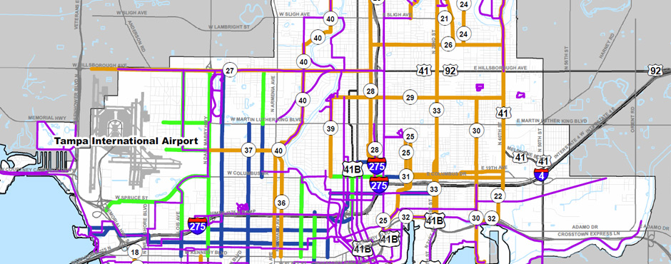
City of Tampa Walk-Bike Project Plan Overview
Tampa Walk Bike Plan Phase I & II Map
Phase I (2011)
Tampa Walk Bike Plan Phase I Report
Tampa Walk Bike Plan Phase I Technical Appendices
Phase II (2012)
Following the successful completion of the Phase I Walk-Bike Plan, again working in close coordination with the City of Tampa, the MPO has completed Phase II of the City of Tampa Walk-Bike Plan. This Phase expands the Plan beyond the three business centers to identify bicycle and pedestrian candidate projects to complete a network within the Interbay Peninsula and throughout west, central, and east Tampa.
Tampa Walk Bike II Final Report
Phase III (2013)
Phase III of Tampa’s Walk Bike Plan has two major objectives. The first objective is to complete the coverage of the City by identifying bicycle and pedestrian connectivity opportunities in the area north of Fletcher Avenue (New Tampa). The second objective is to work with the Green ARTery community organization, City of Tampa Transportation Division, and City of Tampa Planning Division to refine the Green ARTery “Perimeter Trail” concept.
Walk-Bike III New Tampa Final Report
Walk-Bike Plan Phase III Executive Summary
Walk Bike III Final Green ARTery Trail Report
Phase IV (2014)
Walk Bike IV is a product of the city of Tampa’s Multimodal Transportation Impact Fee Study produced in 2104. An aspect of providing enhanced mobility options is the identification, prioritization and eventual implementation of cost feasibility bicycle and pedestrian infrastructure projects. The documents are provided courtesy of the city of Tampa.
Phase V (2016)
The study identifies an implementable route for a bicycle/pedestrian loop trail linking downtown Tampa to the neighborhoods of Palmetto Beach, Ybor City, East Tampa, Live Oak, Woodland Terrace, River Grove, Old Seminole Heights, River Bend, Riverside Heights, Ridgewood Park, Tampa Heights, and along the Hillsborough River back to downtown Tampa. The loop, known as the Perimeter Trail, will connect neighborhoods, parks, and schools along its path.