

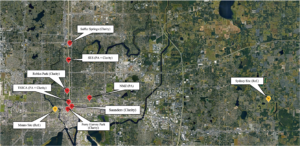
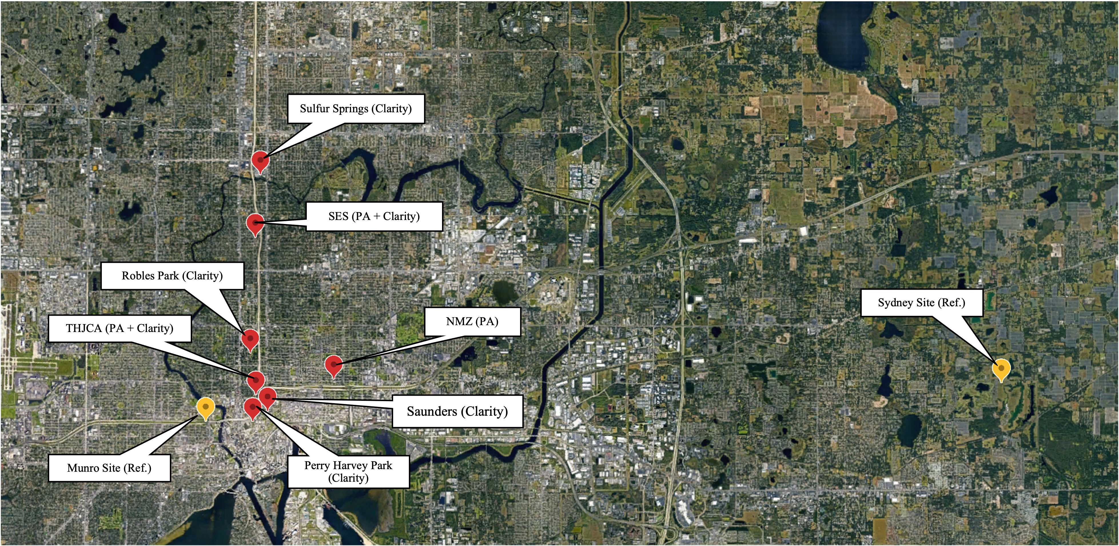
Community Air Monitoring Sites
The Low-Cost Air Quality Monitoring Pilot Study established Community Air Monitoring Sites to help communities and governments understand the air quality where people live, work, learn and play. Community sites host a small, affordable air monitor (e.g. PurpleAir and Clarity monitors) that measure air pollutants. Monitors were also tested at a government regulatory air monitoring site to make sure the data is accurate and reliable. Testing and calibration are ongoing.
Click the links below to view air quality data from the Community Air Monitoring Sites on the PurpleAir Map*
- New Mount Zion Missionary Baptist Church (NMZ)
- Seminole Heights Elementary School (SeminoleES)
- Tampa Heights Junior Civic Association (THJCA)
View the Clarity Open Map and search for “Saunders” to view the Robert J. Saunders Library monitoring data.
*If the sites do not show up change your settings on the map. Set “Averaging period” to “1-hour” and set “Reporting or modified within” to “All-time.”
Project Overview
This project uses low-cost air quality monitors to measure air pollution in communities disproportionately impacted by transportation related air pollution (TRAP) and provides the public access to that air quality data. Community Air Monitoring Sites are established in collaboration with the community to measure hazardous pollutants from vehicle traffic. This pilot phase will teach us about localized air quality in our communities, so the Transportation Planning Organization (TPO) and the community can develop future transportation plans to improve air quality in communities near roadways and improve the equity outcomes of transportation decision making. The research findings and community input will shape methods for a larger scale network of community monitoring sites following the pilot study. The Pilot Study Fact Sheet provides an overview of the study.
The study is sponsored by the TPO and conducted in collaboration with the University of South Florida (USF), Hillsborough County Environmental Protection Commission (EPC), and Federal Highway Administration (FHWA).
What will this study accomplish?
- Collaborate with the community to establish pilot community monitoring sites.
- Research pollutants (particulate matter (PM 2.5) and nitrogen dioxide (NO2)) near roadways to better understand local air quality conditions.
- Provide public access to and increase awareness of the air quality data.
- Develop methods to build a larger network of low-cost air quality monitors in our communities.
Why care about air?
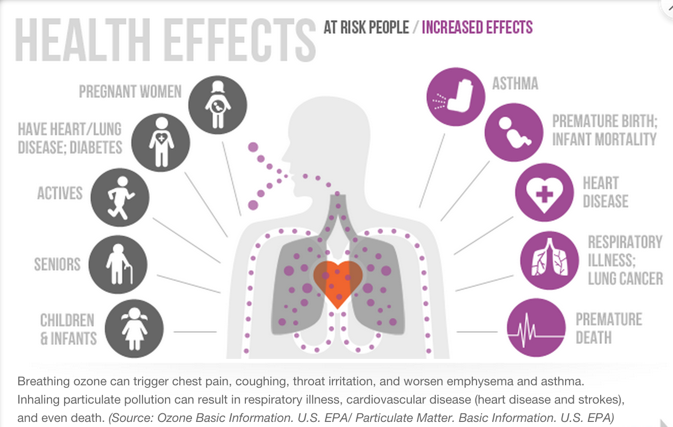
The quality of air we breathe has a significant impact on our health and the environment where we live, work, and play, and pollution directly affects air quality. Continued growth in the county brings an increase of vehicles, construction, air pollutants, and pollutant-related health risks. Therefore, this study looks at environmental and public health factors related to air quality and those who are most affected by air pollution near roadways.
Environmental and Public Health Factors
- Transportation related air pollution (TRAP) is a mix of air pollutants from exhaust, fuel evaporation, wear of brakes, tires, and the roads themselves.
- TRAP peaks near roadways. Residents and businesses who reside along roadways are disproportionately affected by highway traffic and TRAP-related health concerns.
- TRAP is a community health problem known to cause excess mortality, increased health costs, loss of work productivity, and increased rates of asthma, premature birth and/or infant mortality, heart disease, respiratory illness, and lung cancer.
- Nearly one-fifth of Hillsborough County’s total population lives within 300 meters of a high-volume road, and this figure is 13% higher among vulnerable populations.
- Approximately one-quarter of those living within a community experiencing any combination of low-income, high proportion of racial and ethnic minorities, zero-vehicle households, limited English proficiency, and individuals with disabilities are exposed.
- In Hillsborough County, studies show that African Americans and households living in poverty bear a higher burden of exposure to near-road air pollution.
- Many neighborhoods along I-275 and I-4 are underserved communities that experience low-incomes and have a high proportion of racial and ethnic minorities, zero-vehicle households, limited English proficiency, and individuals with disabilities.
- Increased air pollution is a lasting impact of highway construction in Hillsborough County beginning in the 1960’s that displaced families and communities in prominent African American neighborhoods, such as Central Avenue, and immigrant neighborhoods, such as Ybor City.
- In the context of transportation planning, Environmental Justice (EJ) seeks to avoid, minimize, and mitigate the disproportionate distribution of negative environmental and health impacts of transportation projects in low-income and minority neighborhoods. EJ also requires meaningful participation in decision-making on issues related to a healthy environment.
- A more thorough understanding of air quality in communities will enable the TPO to help achieve EJ goals; for example, the TPO can develop future transportation plans that offer more equitable protection from environmental and health impacts of traffic-related air pollution (TRAP).
- The Air Quality Monitoring Pilot Study supports Plan Hillsborough’s Nondiscrimination and Equity Plan, adopted in 2021, and the federal EJ initiative under the Environmental Protection Agency (EPA), through examining existing disparities in traffic-related air pollution across Hillsborough County communities.
About the Monitors
USF researchers researched and selected low-cost air quality monitors based on the following factors: the type and number of pollutants monitored; data collection, storage, and communication; monitor and installation costs; longevity and product support; and prior studies that tested the reliability of the monitor.
The low-cost monitors were installed at the Hillsborough County Environmental Protection Commission (EPC) regulatory air monitoring site near I-275. USF tests and compares the data between the monitors used in the the community air monitoring network and the EPC regulatory monitor to ensure data accuracy and reliability.
For more information about low-cost air quality monitors, see the FAQ section below.
PurpleAir-PA-II monitor
USF Researchers installing PurpleAir Monitors at the Hillsborough County EPC Munro Street Air Monitoring Site.
Clarity Node S Monitor
Community input on air monitoring sites
Ethermap: AQ Monitoring Pilot Study 2022
The sites identified on this map are suggestions from a focus group with community organizations and agencies and input from the project webpage.
The red boundary markers outline the three pilot study communities.
Visit Map
Get involved
Oct 21 – Mar 22
- Identify community monitoring areas
- Install pilot monitors at EPC regulatory site; begin testing
- Engage community partners; focus group
- Select community monitoring pilot sites
- Apply for EPA ARP Enhanced Air Quality Monitoring for Communities Grant
Apr – Sept 22
- Establish Community Air Monitoring Pilot Sites
- Collect and analyze community air quality data
- Public engagement with community sites
- Present findings
Oct 22 – Mar 23
- Report Findings
- Co-locate monitors at control site
- Continue data collection and analysis
- Public engagement
- Develop calibration methods
- Develop training
- Establish Community Air Monitoring Pilot Sites
Apr – Sept 23
- Expand Community Air Monitoring Network upon award of EPA ARP Enhanced Air Quality Monitoring for Communities Grant
- Continue long-term data collection and analysis
- Continue calibration methods
- Public engagement; disseminate training materials
Tell us
We want to hear any suggestions, questions, or concerns you have about the Low-Cost Air Quality Monitoring Pilot Study.

Frequently Asked Questions
What are low-cost air quality monitors?
‘Low-cost’ is the term being used in the research and practice world for an emerging type of innovative monitors that measure air quality. They are smaller and more affordable than national and state regulatory air monitors, and with a lower price and smaller size, more monitors can be dispersed across a greater area to capture more air quality measurements. Low-cost monitors are gaining popularity across the country and worldwide among individual residents and local agencies due to their ease of use and opportunities to share crowd-sourced air quality data (e.g. PurpleAir’s Real-Time Air Quality Map). The US Environmental Protection Agency provides additional information on air quality monitors at https://www.epa.gov/air-sensor-toolbox.
Why are low-cost air quality monitors being used in my community?
The cost of regulatory monitors is a big reason why there are so few such monitors in the county. For instance, a regulatory monitor for one pollutant can cost about $50,000 per year to operate. low-cost air monitors are a way to expand air quality measurements and supplement regulatory data. Researchers and monitoring companies are currently putting in a lot of work to evaluate and develop lower-cost monitors that simultaneously provide reliable air quality data and still make community air measurements affordable and possible. The US Environmental Protection Agency provides additional information on air quality monitors at https://www.epa.gov/air-sensor-toolbox.
Documents
Past Presentations & Events
Low-Cost Air Quality Monitoring Pilot Study Update, February 2022
Focus Group Presentation 02/25/2022
Focus Group Mapping Activity – Monitoring Site Suggestions 02/25/2022
Community Air Quality Monitoring Pilot Study Update 09082022 PPT
Community Air Quality Monitoring Pilot Study Update 09082022 Video
Low-Cost Air Quality Monitoring Pilot Study Final Report 2023
Maps
Ethermap: AQ Monitoring Pilot Study 2022
Map Password: airquality

Contact
Allison Yeh, Transportation Planning Organization
T: 813-272-5940
yeha@plancom.org
Contact
Lizzie Ehrreich, Transportation Planning Organization
T: 813-272-5940
ehrreichl@plancom.org