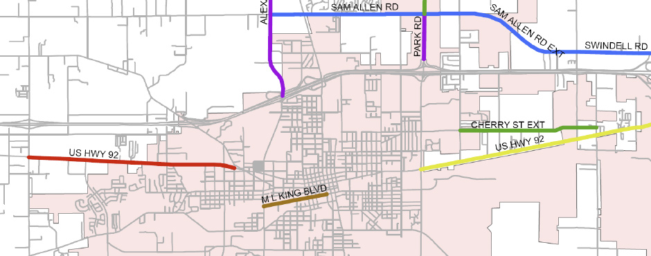
 The City of Plant City, in a coordinated effort with the Hillsborough County Metropolitan Planning Organization (MPO), has developed a Right-of-Way Preservation Map to identify future right-of-way needs for anticipated expansions to the transportation network within the City of Plant City and adjacent portions of unincorporated Hillsborough County.
This map implements Policy 1.F.1 in the Transportation Element of the Comprehensive Plan for the City of Plant City, which states as follows:
TE Policy1.F.1: Within one year of the effective date of this Element, the City shall develop and adopt a right-of-way preservation map for the purposes of preserving corridors for transportation use. The right-of-way map shall provide general alignments and standards for all transportation corridors and support development patterns as defined in the Future Land Use Element.
In addition to the creation of the map itself, this report documents the component analyses, including the review of existing plans and studies used to determine the study network, the review of the implementing jurisdictions’ standard cross sections, and the evaluation of drainage and wetlands impacts. Furthermore, this effort includes two related analyses that were conducted to meet the City’s ongoing transportation planning needs: 1) a detailed evaluation of selected roadways within the City for potential bicycle and pedestrian facility improvements, and 2) identification of preliminary recommendations for long-term strategies that could be employed to improve the operating capabilities of selected intersections.
The Primary output of this City/MPO initiative is the Right-of-Way Preservation Map. This map is intended to assist the City in preserving corridors that will be necessary to implement identified long-term expansions to the transportation network. The mapping process began with a review of existing plans and studies to identify the study network corridors and their future year lane needs. The process then continued with a review of jurisdictional standard cross sections to calculate the necessary right-of-way widths for those corridors.
Plant City Right-of-Way Preservation Map & Related Analyses (2010)