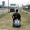
Category: Pedestrian/Walking
-
Busch Boulevard Accessibility Evaluation (2006)
The purpose of this study was to evaluate specific areas on Busch Boulevard where the accessibility of sidewalks, intersections and transit stops can be improved. To inform transportation agencies and local governments of Americans with Disabilities Act (ADA) and other access issues important to citizens with disabilities. To provide an example of how to institute […]
-
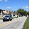
George Road Walk/Bike Connector and Complete Street Study (2016)
The George Road Connector Study took place over a two year period from February 2013 to February 2015. The task of the study is to recommend a connecting trail or other walk/bike facility that would provide links to neighborhood assets in the Town N Country (TNC) community and close a gap between the regionally significant […]
-
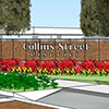
Collins Street (SR 39) Complete Streets Study (2014)
SR 39 is currently a state-owned road that provides one of the few north-south movements through eastern Hillsborough and Pasco counties. In 1988, the Florida Department of Transportation (FDOT) conducted a Project Development and Environment (PD&E) Study for the widening of SR 39 from I-4 to US 301. Early in the study process, it was […]
-

Bicycle Safety Action Plan (2011)
Winner of the 2012 Transportation Planning Excellence Award! The Tampa Bay Area is recognized as one of the most hazardous places in the country to bicycle with a total of 12 fatalities in just one year. Hillsborough County’s fatality rate is over twice the national average. In light of these facts and at the urging […]
-
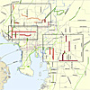
Pedestrian & Bicycle High Crash Areas Strategic Plan For Unincorporated Hillsborough County Roads (2012)
The purpose of this task is to identify existing traffic safety concerns and provide recommendations which will be used as a tool in prioritizing pedestrian and bicycle safety improvements which should be gradually implemented through available funding for key corridors within unincorporated Hillsborough County in order to achieve safer, more convenient, and comfortable travel for […]
-
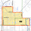
USF Area Multimodal Study (2010)
The Hillsborough County Metropolitan Planning Organization (MPO) and the Hillsborough County Planning and Growth Management Department worked in partnership with stakeholders and local residents to plan for a Multimodal Transportation District (MMTD) in the University of South Florida (USF) area of Hillsborough County. The goals of this effort are to facilitate the use of multiple […]
-
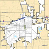
Plant City Multimodal District Study (2007)
The members of the City of Plant City and its community have expressed interest in providing friendly conditions for walking, bicycling, and transit. Meanwhile changes in Florida Statute have required the City of Plant City to implement a proportionate “fair share” ordinance and clearly demonstrate the financial feasibility of the Capital Improvement Element (CIE) within […]
-
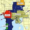
City of Tampa Multimodal District Study (2007)
The City of Tampa and its community members have expressed interest in providing welcoming conditions for walking, bicycling, and transit. Meanwhile, changes to Florida Statute require the City of Tampa to implement proportionate a “fair share” ordinance, clearly demonstrating the financial feasibility of it’s Capital Improvement Element (CIE) and update its Transportation Concurrency Exception Areas […]
-
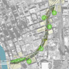
Selmon Greenway Feasibility Study (2010)
Traversing the southern and eastern portions of downtown Tampa, the Lee Roy Selmon Expressway provides a critical link between South Tampa, Brandon, and neighborhoods beyond. The Selmon Greenway is a proposed multi-use trail that will closely follow the expressway alignment to provide pedestrian and bicycle access throughout the downtown area. The Greenway will provide opportunities […]
-

Livable Roadway Guidelines (2006)
This document is an update and consolidation of two documents: Livable Roadways: Proposals for Roadway Appearance and Function and Guidelines for Landscaping Hillsborough County Roadways. In the late 1980’s the Planning Commission included policies and guidelines for establishing and protecting a system of scenic corridors in the comprehensive plans for Hillsborough County and the City of Tampa. In response to […]
-
Walk/Bike Plan for the City of Tampa (2016)
In 2009, the City updated its Comprehensive Plan to encourage growth within the City’s three core “Business Centers” (Downtown, Westshore, and USF), along major transit corridors, and within designated “Mixed-Use Corridors and Villages.” In order to serve the mobility needs of existing and future residents and businesses, it is necessary to narrow down past transportation […]
-
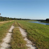
Tampa Bypass Canal Trail Feasibility Study (2013)
The proposed concept consists of a multi-use trail running along the west side of the Tampa Bypass Canal. The vision is to connect the Flatwoods Park in New Tampa through Wilderness and Trout Creek Parks and run south to the McKay Bay Trail, the Selmon Greenway and the South County Trail. This 17-mile multi-use trail […]